Now viewing articles in the category Technology.
Innovation Webinar 10/15: sUAS for Wetlands & Storm Control Monitoring
October 7th, 2020
This session will include presentations on two pilot studies that were conducted by the MassDOT Highway Division in collaboration with the MassDOT Aeronaut...
Cemetery Surveys by sUAS
January 8th, 2020

The towns and villages of New England are steeped in history, and much of it can be seen in the cemeteries and burying grounds dotted across the region. In many cases, town cemeteries date back two or three centuries or more and are still operating today. The records for these cemeteries are usually a mix of hand-written, typed, paper and digital information as record-keeping practices and technology have evolved over the years.
America's Water Infrastructure Act of 2018 Requirements
July 2nd, 2019
America’s Water Infrastructure Act (AWIA) was signed into law in October 2018. This amendment to the Safe Drinking Water Act requires that community water systems serving more than 3,300 people must develop or update Risk and Resiliency Assessments and Emergency Response Plans.
PFAS - An Emerging Contaminant
June 26th, 2019
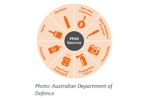
In the past few years, Per- and Polyfluoralkyl substances, commonly referred to as PFAS, have been identified by the USEPA as an emerging contaminant in drinking and surface waters.
Infrastructure Asset Management Systems – What are the best options?
November 30th, 2018
The new NPDES MS4 permit requires municipalities to map and manage their municipal infrastructure for tasks such as catch basin cleaning, outfall sampling, and street sweeping.
How is a map projection like an orange peel?
July 31st, 2018
You may remember your eighth-grade science teacher explaining map projections using the orange-peel analogy: imagine the Earth is an orange.
Posted in: TechnologyTop 15 Uses for GIS
June 18th, 2018
Wait, what? What is GIS?
GIS stands for Geographic Information Systems. It refers to mapping technology that brings together hardware (computers, mobile devices, GPS units) and specialized software to collect, analyze, and model data about the world around us. It has almost unlimited applications in the public, private, and non-profit sectors.


