How is a map projection like an orange peel?
July 31st, 2018


You may remember your eighth-grade science teacher explaining map projections using the orange-peel analogy: imagine the Earth is an orange. In order to draw a map of the surface of the orange, we have to find a way to flatten the peel onto a flat piece of paper or computer screen. But the orange is a sphere, so the only way to do that is to stretch or cut the peel in some places. Unavoidably, that stretching causes distortion.
There are lots of ways to do this. The more you cut the peel up into small pieces, the easier it is to flatten them without too much stretching—but you’re left with a mess of little pieces. If this is a map, it won’t be a very convenient one. But if you leave the pieces large, or don’t cut the peel at all, then it will have to stretch a lot to flatten onto the page.
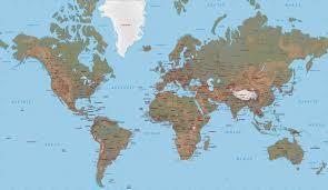
This is the Mercator projection where the peel (that is, the Earth’s surface) is left whole. The equatorial region does not stretch, but as you go toward the poles, the surface has to stretch more and more in order to stay the same width as the equator. The polar regions, which are actually quite small, appear to be enormous. Greenland is not really the same size as the African continent! The Mercator projection is accurate only in the equatorial regions.
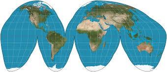
Below we see the projection known as the Goode-Homolosine. In this projection, some cuts are made so that the surface doesn’t have to stretch as much at higher latitudes (closer to the poles). The cuts were made along lines of longitude running through oceans so that the land masses are not split up, but in fact they could be made along any longitudes. If you printed this on a piece of paper and cut it out, you could almost bring the edges together and make a sphere again.
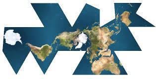
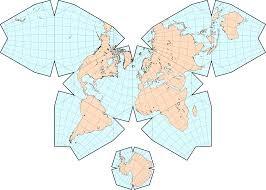
There are many other global projections, but they are all necessarily a compromise between geographic accuracy and convenience of design. The two examples above forego some accuracy for the sake of simplicity and ease of use. Below are two examples that tend the other way, preserving geographic accuracy at the expense of convenience. They accurately reflect the relative sizes of the land masses but it’s a bit difficult to reconcile them with our mental image of the globe.
If you want to map only a portion of the Earth’s surface, there are projections that are better suited to certain latitudes, continents, regional sizes or shapes. These will be discussed in a future blog post.
For more information, feel free to contact me at [email protected].

